Where Are Milestones?
To find milestones or other waymarkers you can access the Milestone Society in-house database as detailed below.
There are also a variety of other sources you may wish to investigate:
Ordnance Survey maps show milestones (MS or MP) and boundary stones (BS) and are a good starting point but it’s not a definitive source. Many milestones shown on the current mapping are no longer in place and some that are in situ are not shown!
Old Ordnance Survey maps, which can be accessed at: https://maps.nls.uk/ are another excellent resource. In addition to showing the location of milestones, they usually show destination and distance information in one or two directions. Such information is a significant help in identifying the original inscription where it is now missing owing to weathering or damage.
Some milestones and waymarkers are Listed Buildings and can be found through a search of the relevant links given in Developing the Database below.
Many milestones and waymarkers are also recorded in local Heritage Environment Records. The majority of these can be accessed and searched through the Heritage Gateway: http://www.heritagegateway.org.uk/gateway/advanced_search.aspx
The Milestone Society Database - some background
The current Milestone Society Database holds over 30 thousand records of waymarkers across the British Isles. An excellent resource and we hope you enjoy discovering it. It has been collated by our enthusiastic members over more than 20 years.
The original surveys used manual record sheets with a comprehensive range of attributes noted. In a pre-smartphone world most of them were accompanied by hard copy photographs that have subsequently been scanned. A significant proportion of this work was undertaken by one of our founder members, Alan Rosevear.
The advent of Google Earth Mapping and ready availability of digital photography allowed us in 2010 to create the Repository website. This provided on-line image files and included spreadsheets with abstracted details of milestones and a variety of other roadside heritage features.
To encourage wider access we duplicated our image files in 2019 onto the www.Geograph.org.uk website which contains over 6 million photographs across the British Isles. This is now the primary resource for the Milestone Society photographs. Information on the Geograph site from other users can also usefully supplement our own records. You can find directions for searching the site content here.
Discover the Database
If you click on the links below to the Google Earth or OpenDocument Spreadsheet files, you will see a list of milestones and waymarkers by type:
- Milestones
- Boundary Markers
- Wayside crosses
- Modern Waymarkers
- Canal Milemarkers
- Fingerposts
- AA Signs
- Tollhouses
Each file shows the month it was most recently updated. The published information are extracts from our master database with key details for each record.
Copyright
The photographs and hyper-links in the Google Earth files, Excel spreadsheets and search results are derived from a number of sources and you should observe the copyright policies of those sources, for example the links to Images of England, Geograph and Flickr.
Where the photographs shown have been provided by individuals, whether members of the Milestone Society or otherwise, these are displayed as ‘thumbnails’ (low resolution images) and are not intended for commercial use. You may use them for personal research or for PowerPoint presentations to other bodies, for example, but you must attribute them to ‘The Milestone Society’.
Developing the Database
There are still milestones and waymarkers being discovered that haven’t been logged in our database. If you think you’ve found one then please get in touch!
A guide to what items we would include in the database can be downloaded here; and advice on suitable photographs is provided here.
To add information to our database or report inaccuracies or changes, please complete the SUBMIT form below, or email our Database Manager, [email protected].
Please make sure you include an accurate Ordnance Survey grid reference for the location of the waymarker. There are free smartphone grid reference apps such as OS Locate – just search ‘grid reference’ on the Play Store / App store.
Other information to note is:
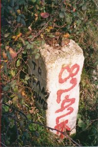
- the text of any inscription;
- position (e.g. on eastern verge, in front of No.23 High St);
- condition (e.g. milestone is leaning; lower text buried)
- date the information was recorded/ photographed
- the name/ number of the road it’s on if applicable
- the parish where it’s located if known
- Is it listed? Search by country at:
- If you provide a photograph it must be freely available for use under a Creative Commons Licence so it can be uploaded to the Geograph website.
NOTE: photographs of items located on private property will only be accepted for publication if the item can be viewed from a public highway/ road; a public right of way; access land or a towpath. The Milestone Society does not encourage trespass to view waymarkers in the database.
Frequently Asked Questions
Missing milestones, vandalism and theft
A major concern of the Society is the loss of our milestone heritage through deliberate theft, which in view of the massive weight of stones or posts most often involves the plates recording mileages attached to the stones. Milemarkers in place are the property of the authority responsible for the upkeep of the road and unauthorised removal of any part of them therefore constitutes a crime.
The information on this website can help to identify stolen material which may appear at car-boot sales, antique fairs, private properties, etc and even advertised on commercially-based websites. The fact that reliable records with photographs are now being made and an inventory of the nation's milestones collected and recorded on searchable computer databases should help to deter future losses, since identification and proof of provenance should be a straightforward matter.
Members who are aware of theft of a milestone or milepost are urged to report the theft to the police and, importantly, to get a crime number to allow the item to be tracked in future. Some police forces are reluctant to accept such a notification from someone who is not the 'owner' or loser of the stolen item, but a definitive statement from Warwickshire Constabulary points out:
Any person is able to make a complaint of an offence if armed with the evidence to create the grounds for, or suspicion that an offence may have occurred.
The recording standards would be slightly different, as the Crime would need to be recorded with the force that related to the loser's address. However, if that is not known then it can be reported with the information known at the time and checked back in order to try and find the original loser. If an item is identifiable by specific detail then the investigation could commence with any force.
So provide the details of location, when last seen as well as other known information. If it's an Historic England 'listed' artifact and it appears on eBay, that is sufficient evidence of theft! Do inform the local authority as well, since they are the 'loser' - the Conservation Officer, the Highways Liaison Officer or the local Councillor.
Also, it is useful to report the theft to Salvo, where a register of such stolen items is advertised - please contact Rob Caldicott, the Society's theft co-ordinator.